
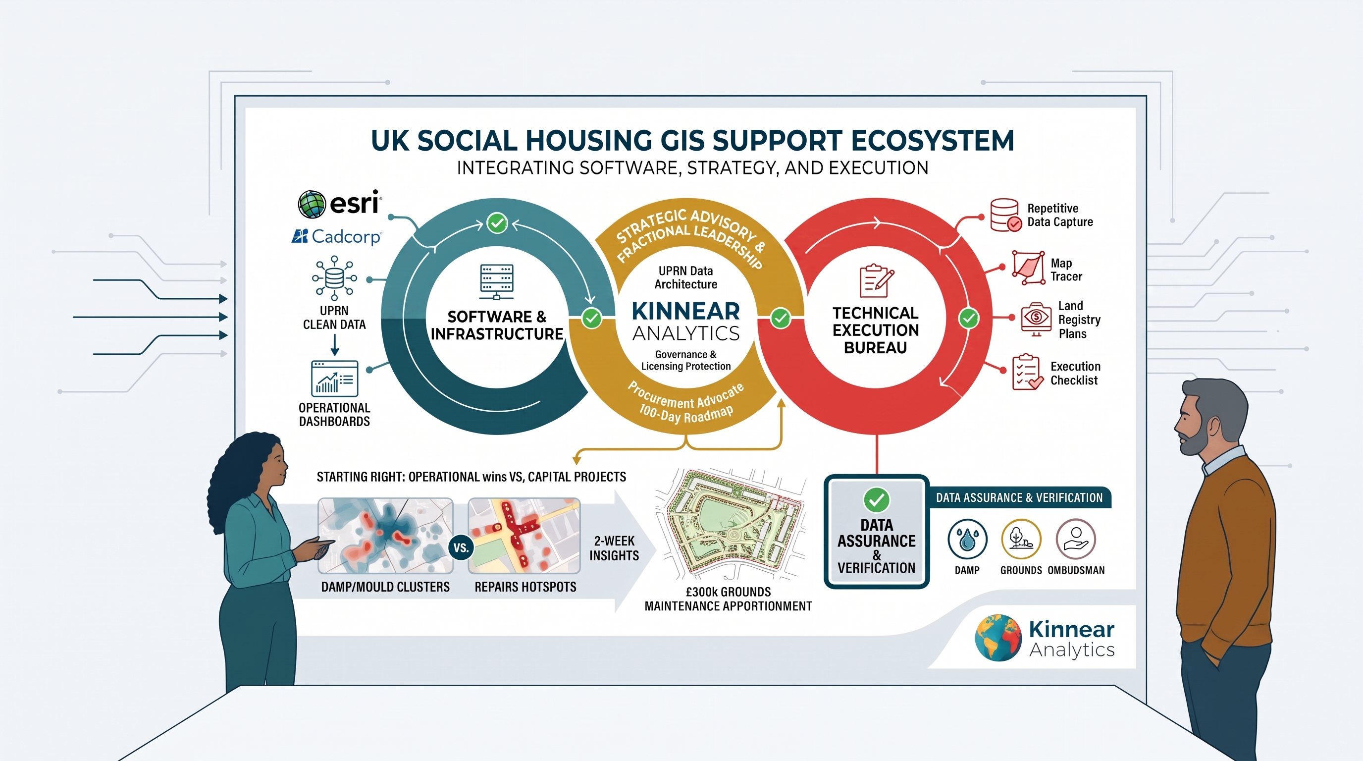
Executive teams across UK social housing increasingly understand that location intelligence is essential for damp and mould compliance, estate management, and stock condition reporting. However, knowing that spatial data holds the key and successfully integrating it into executive decision-making are two very different things.
When a Housing Director or Head of Asset Strategy looks to establish or expand GIS capabilities, they encounter a complex landscape. Without a clear strategic roadmap, housing providers frequently overspend on software seats, struggle to recruit or direct technical personnel, or stall their mapping initiatives before delivering tangible business value.
Navigating the UK social housing GIS support ecosystem requires understanding how to overcome headcount and funding constraints, and balancing rapid operational quick wins against major capital mapping projects.
1. The Capacity & Funding Dilemma
For many housing associations, the primary obstacle to developing a GIS capability isn't a lack of interest—it is headcount friction and structural funding.
Housing providers are under immense pressure from regulators, the Housing Ombudsman, and residents to demonstrate absolute control over their assets. Yet, securing board sign-off for a new permanent £60k+ senior post, or even £35k+ for a generalist GIS Analyst (plus employment overheads), represents a significant financial hurdle. Committing to permanent salary overheads before proving value to the Board frequently stalls spatial initiatives before they launch, or leaves the organisation lacking the internal capacity to properly support a junior hire.
The operational reality is that small-to-medium housing associations often do not require a full-time, 40-hour-a-week senior spatial analyst at the start. What they actually need is high-level strategic direction, UPRN architecture, and Power BI integration to establish a self-sustaining system.
As a result, the analyst gets bogged down creating ad-hoc PDF maps, cleaning flat files, or dealing with basic ticket backlogs. Without a spatial leader above them, they are simply not given the support needed to truly develop an in-house GIS capability.
Developing corporate spatial strategy, building automated Power BI pipelines, and navigating Ordnance Survey PSGA licensing rules require an entirely different, executive-level skill set. Having the right strategic leadership and architectural tools is what ensures technical personnel succeed.
2. The UK Housing GIS Support Landscape: 3 Distinct Tiers
To navigate the market effectively, housing leaders must understand the three distinct tiers of GIS support available in the UK:
- Enterprise Software Vendors (The Infrastructure): Software vendors—such as Esri UK, Cadcorp, or integrated housing systems like MRI—provide foundational software platforms, cloud hosting, and web mapping portals. Their support is geared around system functionality, seat licensing, and software maintenance tickets rather than shaping your internal commercial strategy.
- Technical Execution Bureaus (The Doers): Specialist outsourced data capture bureaus offer hands-on, operational support. They focus on high-volume, repetitive tasks—such as tracing paper title plans from the Land Registry, digitising grounds maintenance boundaries, or hosting managed desktop viewer portals. They are ideal when an association has a clear strategy and simply needs technical execution to clear a mapping backlog.
- Strategic Advisory & Fractional Leadership (The Architects): Strategic consultancies like Kinnear Analytics focus on spatial data architecture, UPRN hygiene and licensing governance, vendor-neutral procurement advice, Power BI analytics, and 100-day implementation roadmaps. Strategic advisors ensure spatial analytics directly informs board-level decision-making without pushing proprietary software seats.
3. The Smart Alternative: Fractional Strategic Partnership
When internal capacity is constrained, associations often attempt to "tack" GIS responsibilities onto an existing generalist, such as an IT administrator, Data Analyst, or Asset Officer. This approach almost universally fails, leading to underutilised software, broken spatial databases, staff frustration, or GIS becoming siloed in a single department like assets or grounds maintenance.
Engaging a Fractional Strategic Partner provides a proven alternative. By bringing in an experienced spatial lead on a flexible, non-permanent basis, housing associations gain executive-level spatial strategy, UPRN data architecture, and dashboard development for a fraction of a full-time salary—eliminating permanent headcount risk while establishing robust governance.
4. Starting Right: Why 2-Week Quick Wins Beat a £300k Grounds Maintenance Project
Generalist advice in the housing sector often urges providers to "start with Grounds Maintenance" for the best ROI. While the logic is correct, attempting this on Day 1 is one of the most common reasons spatial initiatives stall.
Mapping grounds maintenance across 1,500+ estates and apportioning plots down to individual service charge accounts is a massive undertaking. At a realistic cost of around £200 per estate, a full digitisation and apportionment program represents a £200k to £300k capital project. While this is a Phase 2 capital investment that delivers substantial long-term returns, requesting a £300k budget on Day 1 creates immediate board-level friction.
Instead of delaying progress to negotiate a major capital budget, successful leads deliver rapid, low-cost operational wins using existing data. The below example projects should take under two weeks to complete:
- Repairs & Damp/Mould Clusters: Overlaying job tickets against property age and EPC ratings.
- Complaints & ASB Hotspots: Mapping tenant feedback to identify specific blocks driving service desk volume.
- Fly-Tipping & Waste Management: Mapping recurring clearance costs to reallocate estate caretaking routes.
- Flood Risk & Vulnerable Demographics: Cross-referencing EA flood zones with tenant vulnerability registers for emergency response planning.
- Fire Risk Mapping: Identifying where local fires have occurred near homes to determine what immediate support should be offered to residents.
- Tall Buildings: Mapping known, or suspected, tall buildings in relation to your stock for safety and compliance monitoring.
- Deprivation Levels: Overlaying Index of Multiple Deprivation (IMD) deciles against your property points.
- Community Investment: Mapping homes in line with where community funding is being allocated, cross-referenced with demographics and vulnerability data to ensure equitable support.
Delivering these rapid insights builds immediate credibility and executive trust. Once the Board sees how location intelligence solves day-to-day operational headaches, securing approval for large-scale capital projects becomes a straightforward, highly supported decision.
5. Reframing Grounds Maintenance (Visible ROI vs. High Entry Cost)
To be clear: Grounds Maintenance mapping does deliver the most visible and easily quantifiable financial ROI in social housing. Accurately measuring grass, hedges, and hard standing—and linking those plots directly to leaseholder service charge accounts—can save large associations up to £1M per year through tighter contractor management, fewer tribunal disputes, and fairer billing.
The key is recognizing that GM mapping is a heavy lift. A £200k–£300k project cost is firmly on the higher tier of capital expenditure. Asking for that budget on Day 1 invites unnecessary scrutiny. Delivering 2-week quick wins first creates the exact operational momentum and board confidence needed to get a £300k Grounds Maintenance & Service Charge project greenlit smoothly.
6. Data Foundations & Procurement Protection
Before procuring external software or commissioning bulk digitisation, housing associations must secure their core data foundations:
- Bulk UPRN Matching & Licensing Safety: Unique Property Reference Numbers (UPRNs) are the golden thread of housing data. However, bulk address matching can carry significant Ordnance Survey and PSGA licensing traps - understanding what you have to pay for is key. Establishing clean, compliant UPRN (or even internal property reference values) joins across your Housing Management System (Civica, MRI, Capita) ensures your spatial data connects seamlessly to your core corporate platforms.
- Vendor-Neutral Procurement: Independent advisors act as a buyer’s advocate. By evaluating software tiers and data requirements objectively, strategic advisors protect housing provider budgets, ensuring associations only purchase the licenses and spatial feeds they actually need.
- Scoping Execution Briefs: When the time comes for heavy manual polygon digitising, a strategic partner writes the exact technical specifications and quality criteria before you hire an outsourced data capture bureau, ensuring external work is delivered efficiently and on budget.
7. Establishing Your Spatial Strategy
Building a mature, high-impact GIS capability does not require immediate, heavy capital investment or full-time permanent hiring. By understanding the support landscape, leveraging fractional leadership, and pairing 2-week quick wins with targeted capital projects, housing providers can build a resilient, legally defensible spatial capability.
Ready to assess your organisation's spatial maturity, navigate software procurement, or explore fractional GIS leadership? Read our companion guides, The Social Housing GIS Playbook and The First 100 Days Framework, connect with Chris Kinnear on LinkedIn, or tune into The Housing Geospatial Podcast.