
Joining a UK social housing provider as a new GIS lead, Head of Data, or Asset Transformation Director is both an extraordinary opportunity and a quiet minefield.
In almost every case, you inherit a familiar setup: the organisation holds legacy desktop software licenses (such as Cadcorp or Esri), a desktop folder filled with shapefiles, and a housing management system (HMS) loaded with address data. Yet, despite holding thousands of location-bound assets, spatial intelligence is rarely integrated into executive decision-making.
The immediate temptation is to dive straight into buying updated data, do 'routine' operational work—cleaning boundary polygons, answering ad-hoc map requests, or procuring shiny new web portals. However, jumping into execution before establishing strategy is the primary reason housing GIS initiatives stall.
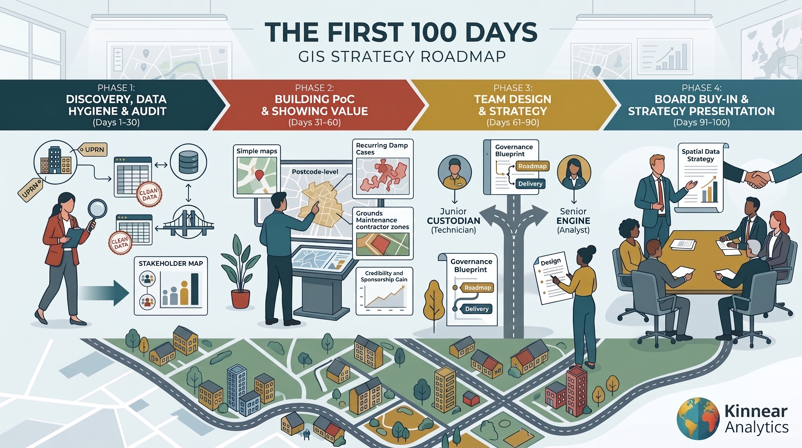
To build a high-impact, sustainable spatial capability, you need a structured approach. This 100-day framework outlines how to navigate data discovery, align stakeholders, deliver rapid proof-of-concept visualisations, and design the right team for long-term success.
Part 1: The Day 1 Dilemma—Avoiding the "Software-First" Trap
When new spatial leads take the reins, vendors often encourage them to immediately upgrade software tiers or buy additional cloud seats. However, software does not equal capability.
Without clear resident and commercial objectives, expensive spatial stacks become shelfware. The goal of your first 100 days is not to install a web map—it is to position spatial analytics as an essential operational enabler to support residents. We can do this through damp and mould compliance, grounds maintenance, land title audits, and asset investment.
Part 2: Days 1–30—Discovery, Data Hygiene, and Stakeholder Mapping
The first month is about understanding your baseline infrastructure and building the human network needed to support your vision.
1. The Data Hygiene & Interoperability Audit
Before designing dashboards, evaluate your underlying data foundation:
- UPRN Coverage: What percentage of your asset repository has validated Unique Property Reference Numbers (UPRNs)?
- Spatial Coordinates: Are there any coordinates linked to an asset? Is so, are they in easting and northing or latitude or longitude? Or, simply, are there no co-ordinates or UPRNs linked to an asset?
- System Interoperability: How easily does your data flow between core platforms like Civica, MRI, Capita, or cloud storage? Do you need to create this bridge between systems?
2. Establishing the Stakeholder Working Group
GIS fails when built in an IT silo. During your first 30 days, identify key operational champions outside of IT and data teams. Set up a regular Spatial Working Group with representatives from:
- Asset Management & Repairs: To track damp, mould, and structural compliance.
- Estates & Grounds Maintenance: To resolve land ownership and contractor boundary disputes.
- Income & Legal/Treasury: To review land charging, unmapped assets, and boundary liabilities.
- Front Line Staff: These are the people directly involved in your residents' lives every day. They see what is going on and know where data does and doesn't support them. Be their trusted partner to support your residents
Part 3: Days 31–60—Uncovering Pain Points & Building Quick Wins
Once your working group is established, move from audit mode to demonstrating tangible business value.
1. Pinpointing Stakeholder Pain Points
Interview your working group leads to uncover what questions they currently struggle to answer using traditional tabular reporting. Common sector examples include:
- "Where are our recurring damp and mould cases clustering relative to property age and EPC ratings?"
- "Are we paying contractors to cut grass on land that doesn't belong to us?"
- "Which housing blocks sit inside high flood-risk zones with vulnerable tenant demographics?"
- "Was there a fire near any of our homes and do these residents need any support?"
2. Delivering the Rapid Proof-of-Concept (PoC)
Do not wait for a full enterprise rollout to show value. Choose one pain point from the previous section and map it quickly. Build a quick-turnaround proof-of-concept using lightweight, high-visibility tools:
- Step 1: If you don't have (or trust your) co-ordinates then go to the ONS geoportal and download the postcode data and map everything at postcode level.
- Step 2: Keep it simple. Use a GIS (whether you have an existing one or have to use QGIS) map and analyse that pain point. Find the simplest one to do (usually mapping complaints or repairs) and then present that. It won't be glamourous but it shows how it can look.
- Step 3 - Optional: if you have a dedicated data team or Power BI team, ask if they can support you in making a dashboard showing all of this. Only if they have capacity or capability - the point of this section is to be fast.
Presenting something is better than presenting nothing. And showing how to visualise a known operational headache to the Executive Team builds immediate credibility and secures executive sponsorship.
Part 4: Days 61–90—Team Building, Governance, and Resourcing Strategy
By month three, you will have proven what spatial data can achieve. Now, you must design the internal structure required to sustain it.
1. Designing the Right Team
A frequent mistake in social housing is hiring the wrong profile first. You must decide whether your organisation currently requires a Custodian or an Engine:
- The GIS Technician (The Custodian): Focuses on data entry, boundary digitisation, Land Registry plan mapping, and system administration. This option is the cheapest and should be considered as a 'junior' position for when there is already a spatial specialist in the organisation.
- The Senior Spatial Analyst (The Engine): This senior position should be focussing on supporting the strategy and architecture for advanced spatial analytics, cross-system data pipelines, Power BI integration, and commercial reporting. This option is best when there is no spatial specialism within the organisation.
It is not recommended to hire a standard analyst in the immediate as if your underlying data is chaotic, hiring an analyst too early will cause frustration as they get bogged down in manual cleaning. Conversely, hiring a technician first won't give you the strategic storytelling capacity needed to win Board backing. Many associations benefit from working with an independent strategic advisor to establish governance before making permanent hires.
2. Designing Initial GIS Strategy and Job Specification
Working with your working group, do an initial strategy planning session. Where do you want GIS to be in two, five, and ten years and how will you get there?
From there, design an appropriate job specification in line with the role identified above. It is advised to not be too specific in tools and instead is best to look for personality traits rather than can they use a specific system.
Part 5: Days 91–100—Presenting the Strategy & Securing Board Buy-In
The final ten days are dedicated to synthesising your findings into a formal, board-ready Spatial Data Strategy.
Your business case should outline:
- The Baseline: Current state of data health, legacy system integration, and identified risk exposure.
- The Proven Value: Highlights and ROI from your Days 31–60 Proof-of-Concept.
- The Target Architecture: Detail the software routes (Open Source, Enterprise Cloud, or Embedded Power BI) tailored to budget and technical maturity.
- The Delivery Roadmap: Recruitment plan, phase 1 operational rollout, and data purchasing.
With executive approval secured and job specifications finalised, you can officially commence your recruitment phase or partner onboarding with total confidence.
Stepping into a new GIS leadership role in social housing or looking to shape your organization's spatial roadmap? Read our companion piece, The Social Housing GIS Playbook, connect with Chris Kinnear on LinkedIn, or tune into The Housing Geospatial Podcast.