

If you work in UK social housing, you are sitting on an incredible goldmine of location-based data. Every property asset, tenant repair ticket, stock condition assessment, and grounds maintenance boundary is intrinsically tied to a physical place.
Yet, for many housing providers, spatial data remains trapped in static spreadsheets, isolated in legacy housing management systems, or underutilised due to a lack of clear strategy.
When housing associations decide to adopt Geographic Information Systems (GIS), the immediate question is almost always: "Which software should we buy?"
However, jumping straight into buying software licenses before defining your commercial outcomes is a costly mistake. Choosing the right spatial stack isn't about finding the "best" map tool—it is about picking the right infrastructure for your organisation's budget, technical maturity, and operational goals.
This playbook breaks down what social housing professionals need to know about GIS, how spatial data solves critical sector challenges, and how to evaluate the software ecosystem to make an informed, value-driven choice.
Part 1: Why Location Intelligence Matters in Social Housing
Historically, GIS was seen as a niche tool reserved for dedicated cartographers or planning teams. Today, location intelligence is a core operational enabler across the entire housing executive agenda.
1. Damp, Mould, and Awaab’s Law Compliance
Meeting strict regulatory response windows under Awaab’s Law requires proactive risk identification. Storing repair tickets in one database and stock condition surveys in another creates dangerous blind spots. Visualising these datasets spatially overlays property age, construction type, EPC ratings, and past repair clusters, allowing asset teams to identify at-risk blocks and intervene before a tenant escalates to the Ombudsman.
2. Property Charging and Land Title Audits
Many housing associations lose significant revenue due to uncharged or misallocated land parcels. Spatial analysis maps legal boundaries directly against physical maintenance responsibilities, identifying unrecorded assets, verifying boundary lines, and unlocking hidden value for treasury and legal operations.
3. Grounds Maintenance and Contractor Oversight
Outsourced grounds maintenance contracts are a frequent source of tenant complaints and financial leakage. Digitising land ownership boundaries into interactive web maps gives operational teams and contractors precise, unambiguous grass-cutting and hedge-trimming schedules, eliminating disputes over land responsibility.
4. Tenant Vulnerability and Community Investment
Spatial analysis allows providers to overlay internal tenant data with external datasets, such as the Index of Multiple Deprivation (IMD), access to health services, or flood risk zones. This provides executive leads with the clear visual evidence needed to target community investment and support services where they are most needed.
Part 2: The Core Architectural Approaches
When building or updating your housing GIS capabilities, options fall into two main delivery models: Open Source and Proprietary Commercial Software.
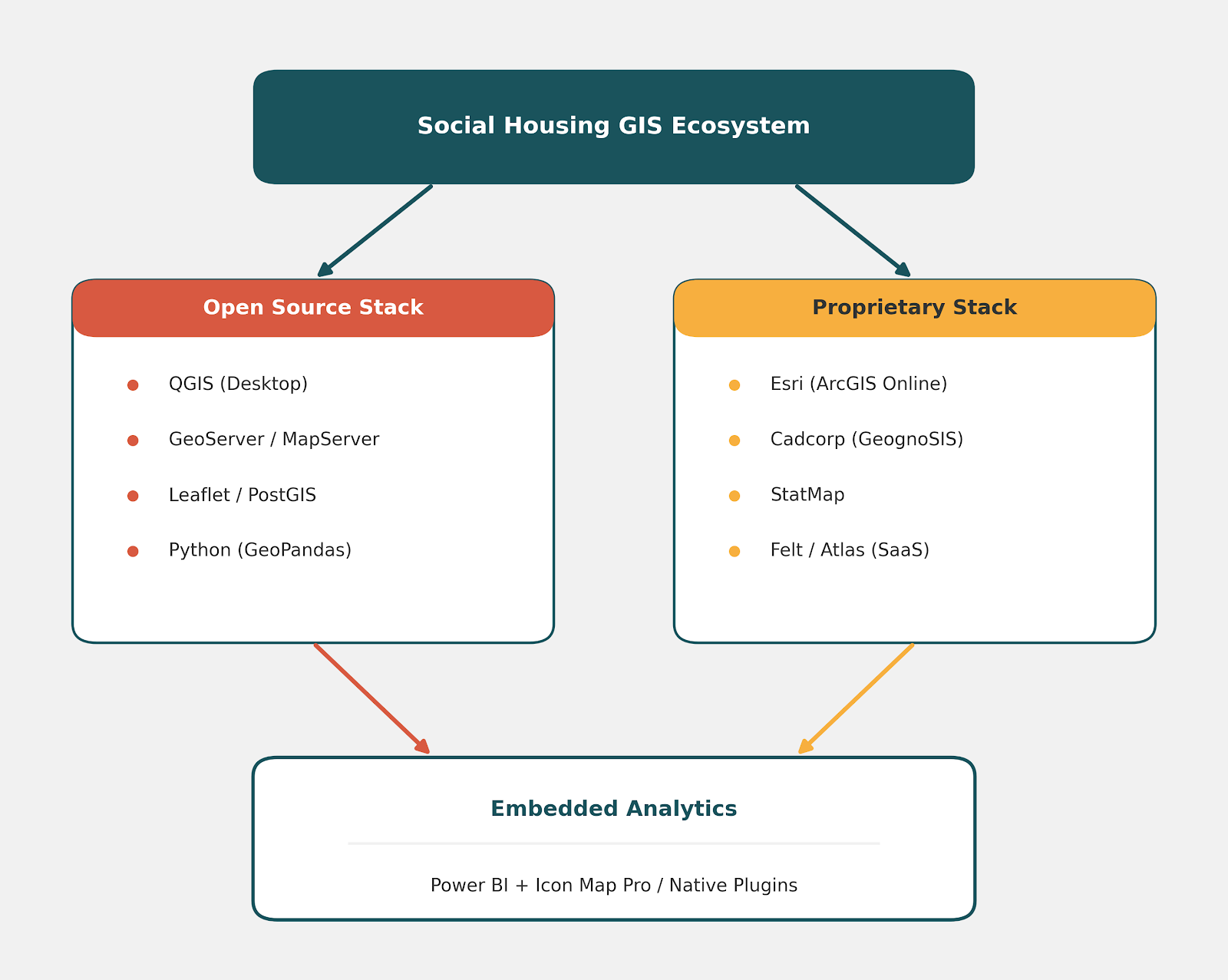
Part 3: Open Source Options—Maximum Flexibility, Zero Licensing Costs
Open-source tools offer complete customisation and remove ongoing license fees. They are ideal for organisations with strong internal data skills or those looking to prove value before committing capital budget.
QGIS: The Gold Standard Desktop GIS
QGIS is a fully open-source, community-driven desktop application. It handles virtually all spatial file formats, features thousands of analytical plugins, and performs complex spatial processing on par with expensive commercial alternatives.
- Best For: Data analysts, asset planners, and GIS specialists conducting deep spatial analysis, boundary cleaning, or batch processing.
- Key Considerations: QGIS is purely a desktop application. To share interactive maps across an organisation, you must pair it with a web-mapping server or cloud distribution platform or specialist plugins.
Custom Web Mapping: GeoServer, MapServer, and Leaflet
To distribute spatial data via a web browser using open-source tools, organisations will typically have to deploy spatial database servers like GeoServer or MapServer, alongside lightweight front-end mapping libraries like Leaflet or MapLibre.
- Best For: Organisations with in-house software developers looking to build fully custom, branded web portals.
- Key Considerations: Requires ongoing server maintenance, IT infrastructure oversight, and developer resources to manage security and updates.
Python & GeoPandas: Advanced Data Automation
For automated data pipelines—such as routinely linking thousands of Unique Property Reference Numbers (UPRNs) to spatial coordinates—Python packages like GeoPandas, Shapely, and PyProj allow analysts to automate complex spatial workflows directly within data warehouses.
Part 4: Proprietary Software—Turnkey Solutions and Sector Specialisation
Proprietary platforms provide out-of-the-box functionality, dedicated technical support, and seamless cloud hosting, making them the preferred choice for turn-key enterprise deployments.
Esri (ArcGIS Online & ArcGIS Pro)
Esri is the global industry giant in GIS. Its ecosystem ranges from advanced desktop software (ArcGIS Pro) to fully hosted cloud platforms (ArcGIS Online). It excels in mobile survey creation (Survey123), executive dashboards, and complex spatial modeling.
- Best For: Organisations requiring a rapid, comprehensive, scalable enterprise spatial infrastructure across multiple departments.
- Key Considerations: Licensing is feature-based and user-tiered. Careful scoping is necessary to ensure you buy the exact license types your organisation needs.
Cadcorp
Cadcorp is one of the most widely established GIS vendors within UK social housing and emergency services. Its platform, built specifically around UK public sector workflows, offers deep integrations with housing management systems (e.g., Civica, MRI, Capita). Its web-mapping engine, GeognoSIS, includes dedicated plugins for business intelligence tools.
- Best For: Housing providers wanting off-the-shelf housing workflows, grounds maintenance management, and direct integration with legacy housing systems.
- Key Considerations: While Cadcorp can host GeognoSIS there is still a development time between purchase and deployment.
StatMap
StatMap is a cloud-first platform widely deployed across UK local authorities and public sector bodies. Rather than acting purely as a general-purpose GIS, StatMap provides specialised modules designed to manage gazetteers (LLPG/BS7666 compliance), address matching, and land management.
- Best For: Local authority housing departments and housing providers requiring tight address gazetteer management and easy web deployment.
Modern SaaS Cloud Platforms: Felt and Atlas
A new generation of web-first, cloud-native spatial tools has emerged to simplify collaboration and speed up map creation:
- Felt: Focuses on real-time collaboration, intuitive drawing, and instant sharing. It features a seamless QGIS plugin, allowing technical analysts to push complex outputs straight to an interactive web map for non-technical stakeholders.
- Atlas: Takes a streamlined approach to spatial analytics, offering a clean, lightweight interface for non-GIS experts who only need core spatial queries, surveys, and visual dashboards without the complexity of traditional GIS suites.
Part 5: Embedded Spatial Analytics—Power BI and Icon Map Pro
Not every staff member needs a standalone GIS application. In fact, forcing non-technical housing officers or operational managers to learn a dedicated GIS tool often leads to low adoption.
Current Power BI visualisations are not good enough to represent spatial information adequately. Standard mapping visualisation can only handle point data - it is not enogh when you want to present other spatial data types into existing Business Intelligence (BI) tools.
Power BI + Icon Map Pro
If your organisation already uses Microsoft Power BI, Icon Map Pro allows you to render complex spatial data—such as polygon boundaries, point clusters, line vectors, and custom map layers—directly inside your standard corporate dashboards.
- Why It Works: It unifies spatial data with financial, operational, and performance KPIs. An executive viewing a stock condition dashboard can filter by region or block without ever leaving the familiar Power BI interface.
- Efficiency: Eliminates additional software training for end-users while maximizing returns on your existing Microsoft license investments.
- Data Interopability: Because the spatial layer sits directly on top of your core data model, interactive cross-filtering works seamlessly. Selecting a property, repair category, or risk score elsewhere on the dashboard automatically filters and highlights the exact spatial locations on the map in real time.
Part 6: Summary & Decision Matrix
Choosing the right spatial stack comes down to matching your technical resources, user requirements, and organisational structure.
| Organisational Profile | Recommended Strategy | Primary Tools |
|---|---|---|
| Small Team / Limited Budget | Start open-source to build the business case without upfront software costs. | QGIS + Power BI (Native / Icon Map Pro) |
| Corporate BI-First Strategy | Embed maps directly into operational reporting where users already work. | Power BI + Icon Map Pro + Cloud Data Warehouse |
| Large Enterprise / Complex Needs | Deploy a full cloud-GIS stack with dedicated mobile surveys and multi-department workflows. | Esri (ArcGIS Online) or Cadcorp or QGIS for desktop spatial analysis and Power BI + Icon Map Pro |
| Collaborative / Agile Teams | Combine robust analytical desktop tools with rapid web-sharing applications. | QGIS + Felt or Atlas |
Taking the Next Step
Technology is only one part of the puzzle. A successful GIS implementation requires a clear data strategy, clean address information (i.e. knowing your UPRNs), and aligned operational workflows.
Whether you are building your first spatial roadmap, migrating legacy mapping software to the cloud, or looking to integrate spatial data into Power BI, focus on the operational outcome first—the software will follow.
Have questions about structuring your housing spatial data strategy? Connect with Chris Kinnear on LinkedIn, listen to The Housing Geospatial Podcast, or join the discussion in the Housing Geospatial Network.